Description
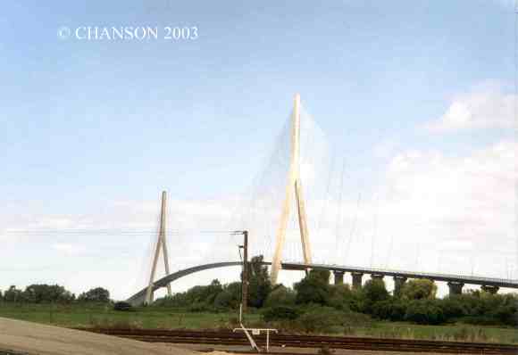
Pont de Normandie, France. Completed in 1995, the Pont de Normandie is located next to the Seine river mouth. It is a suspension bridge. The total length is 2141 m and the central span is 856 m long. The main deck is 52 m above the highest water levels while the pylon height is 214.77 m. There are a total of 184 suspension cables. Cable lenghts range from 95 to 450 m. Part of the deck cantilevering out from the pylons was built as a hollow box made of prestressed concrete, but about two thirds of the deck were made of a steel. The estuary of the Seine river is well-known for strong Westerly winds and the bridge was designed to sustain wind speeds of up to 300 km/h. The bridge deck was streamlined to reduce the wind drag and its design was tested in wind tunnel. The wind reference velocities were an average velocity of 35.3 m/s at 10 m/s above ground, 44 m/s at deck level and 49 m/s at the top of pylon (210 m above water). The bridge deck is a box-girder to increase the torsional rigidity of the bridge and to limit the first torsional period to less than half of the first vertical flexion period. The deck was streamlined to reduce wind forces, with the box-girder height of less than 3.0 m. The design was aimed to reduce vortex shedding by increasing the width to height ratio of the deck. The pylon shape was selected to limit second order effects and to increase its structural capacity to resist wind loads. Although the vibration periods of the cables would have been about 4 seconds, four damping ropes were installed to interconnect the cables and to reduce the first period to about 1.25 seconds. Looking North from the left bank on 2 May 2003.
 Pont de Normandie - France (1)